 ar
ar bg
bg hr
hr cs
cs da
da nl
nl fi
fi fr
fr de
de el
el hi
hi it
it ko
ko no
no pl
pl pt
pt ro
ro ru
ru es
es sv
sv tl
tl iw
iw id
id lv
lv lt
lt sr
sr sk
sk sl
sl uk
uk vi
vi et
et hu
hu th
th tr
tr fa
fa ms
ms hy
hy ka
ka ur
ur bn
bn mn
mn ta
ta kk
kk uz
uz ku
ku
water gauge level
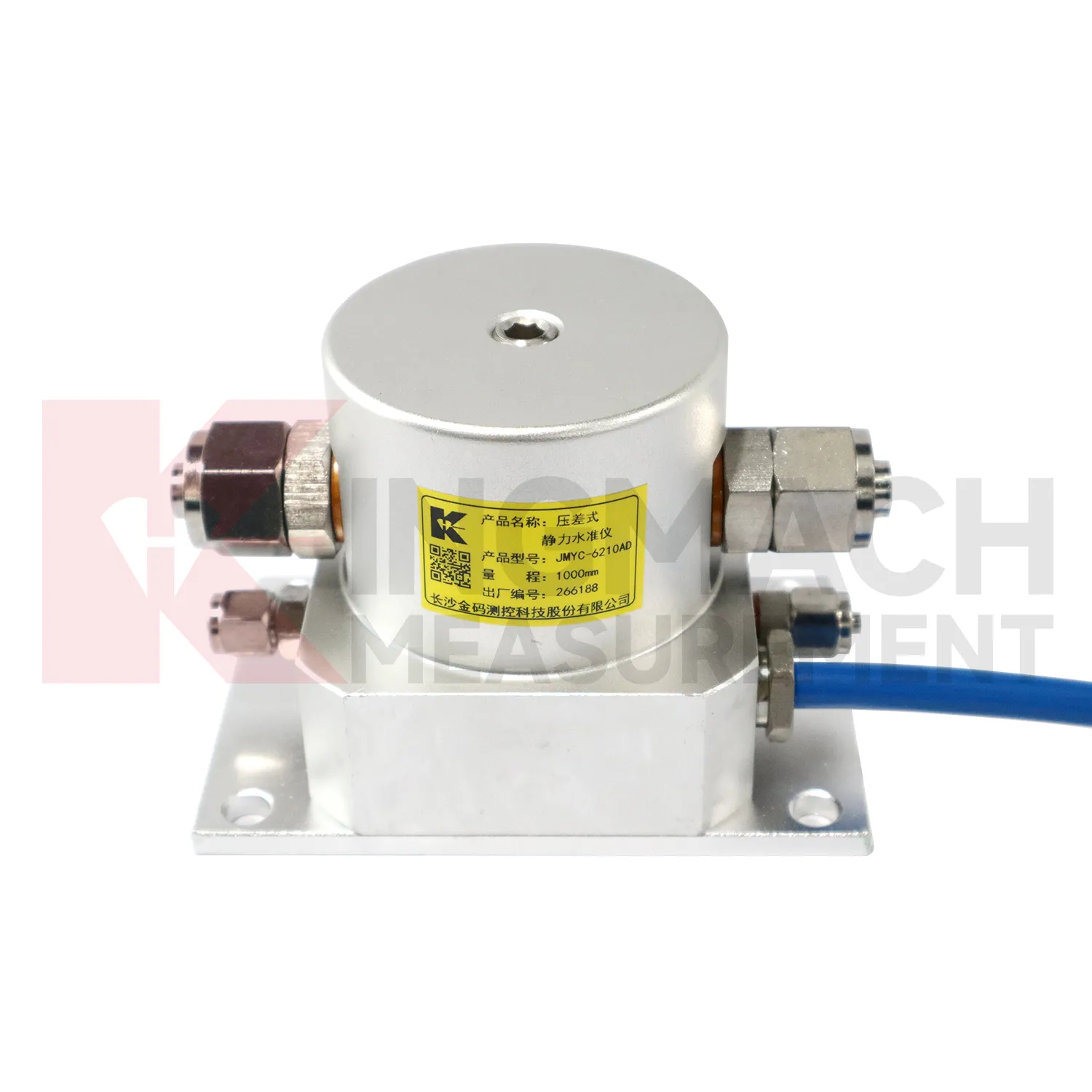
The JMYC-62XXAD wide-range differential pressure hydrostatic level sensor extends Kingmach water gauge level into projects where settlement may be too large for micro range instruments. It works as a reference-point hydrostatic system for uneven pavement settlement, nonlinear cross-section settlement, soft foundation treatment, land reclamation foundations, dam settlement, bridge deflection, slope stability, and building settlement. Published specifications include 500 mm, 1000 mm, 2000 mm, and 4000 mm ranges, 0.1 mm resolution, 0.2%FS accuracy, RS485 output, DC 9V to 24V supply, power consumption below 0.5W, and an operating temperature from -30 degrees Celsius to +80 degrees Celsius. The instrument is especially relevant when a profile may keep moving during filling, preloading, or staged construction. Planning should define the fixed reference point first, then divide the section into measuring locations that can reveal uneven deformation. Cable protection, cabinet access, sensor elevation, and construction vehicle paths need early coordination. When the data is reviewed later, the wide range helps distinguish gradual consolidation from sudden local movement across a road, reclamation area, or embankment section.
Application of water gauge level
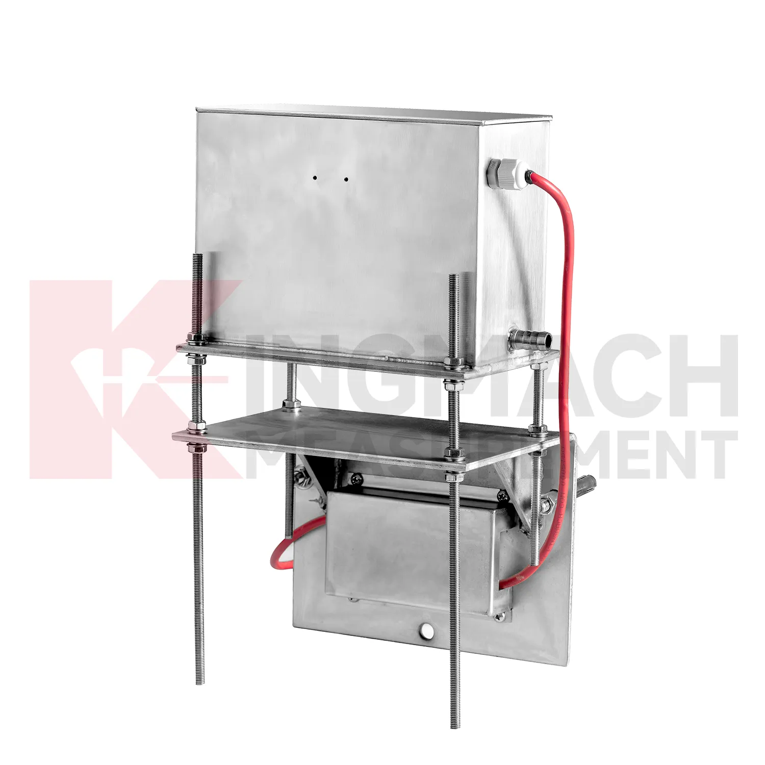
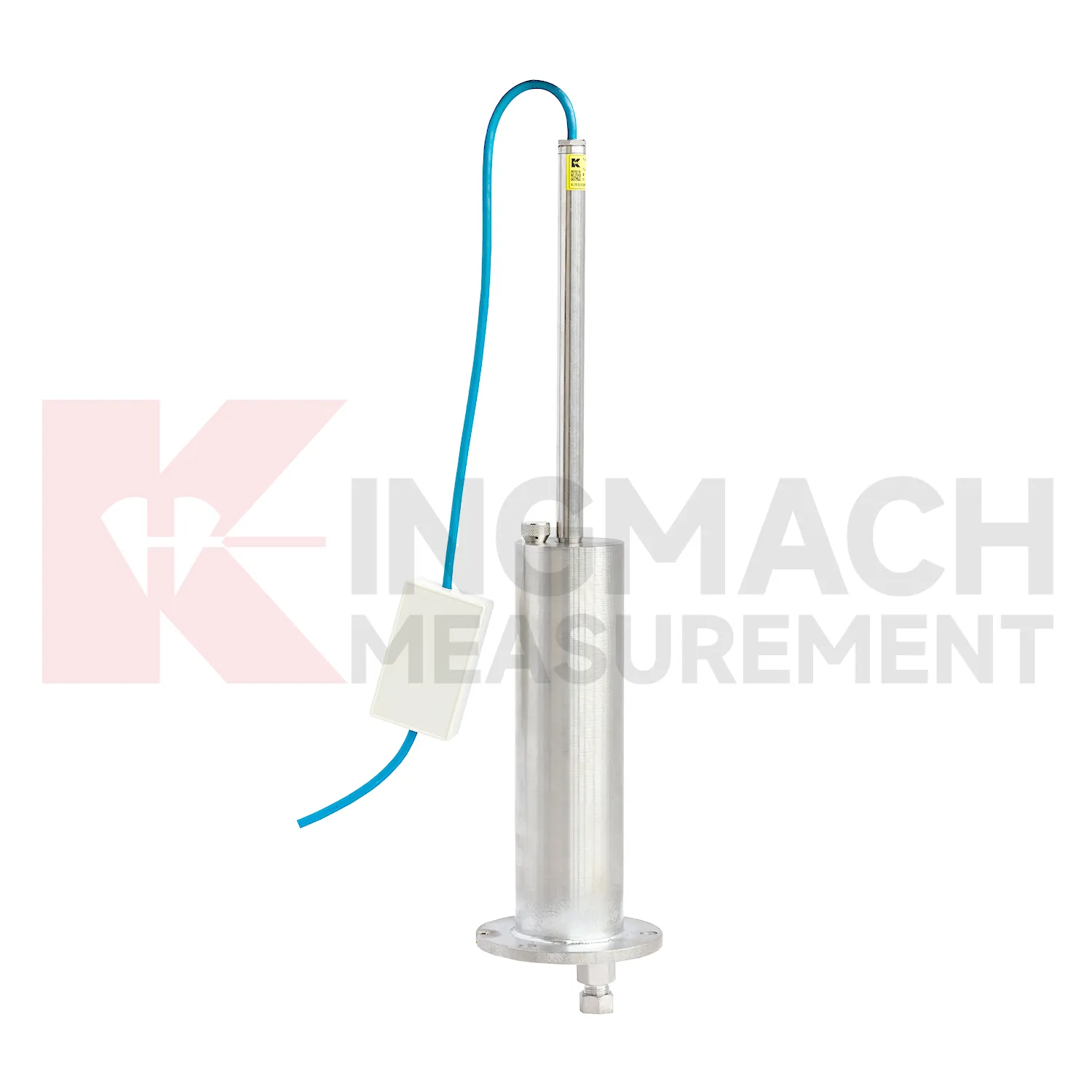
In dam monitoring, water gauge level are used for long-term observation of dam body settlement, gallery deformation, foundation movement, and vertical change near water-control structures. This work has a slow rhythm: reservoir level, seepage, rainfall, seasonal temperature, and consolidation history may all affect the curve. Kingmach JMQJ-62XXADT gives micro range hydrostatic measurement with IP68 protection and 0.01 mm resolution, while JMYC-62XXAD provides wider 500 mm to 4000 mm ranges for larger vertical displacement. JMDL-62XXADT can form a multi-point hydrostatic leveling network when several positions must be compared from one reference. A dam layout should treat the reference location, tube route, cabinet position, cable protection, and access path as part of the measurement system. During operation, engineers should review settlement data with reservoir records, seepage flow, piezometer behavior, inspection notes from galleries, and downstream observation results. The goal is to see whether a slow trend matches expected consolidation or whether it appears near a structural joint, foundation zone, or water level event. Good records make annual dam-safety review more traceable and reduce confusion when readings are checked years later.
The future of water gauge level
Future water gauge level will be specified as part of mixed monitoring packages. Settlement alone may show that a point moved downward, but it rarely explains the cause. A railway subgrade package may combine settlement gauges, rainfall, pore pressure, tilt, and vibration. A bridge package may combine hydrostatic settlement, strain gauges, load cells, temperature, and deflection readings. A foundation pit package may combine single-point settlement, groundwater level, retaining wall displacement, and support force. Kingmach already has product groups across settlement, displacement, strain, load, tilt, environmental monitoring, acquisition hardware, cables, and software. The next practical improvement is selecting the settlement product together with the logger, cabinet, communication route, warning levels, and inspection actions. This lets the monitoring network answer a site question instead of producing separate curves that must be interpreted after the fact.
Care & Maintenance of water gauge level
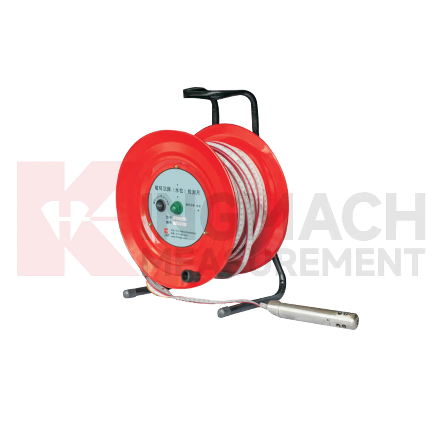
Magnetic ring water gauge level need consistent field habits. For JMCJ-1003/1005, record borehole number, ring depth, water level depth, tape mark, operator, date, battery status, and previous reading each time. The magnetic ring function relies on electromagnetic induction and audible or visual indication, while water level detection responds when the probe contacts water. Different operators should use the same borehole orifice reference mark and the same tape handling method. After field work, clean the probe, dry the reel, inspect the tape cable, check the battery, and note any weak alarm or rough movement in the borehole. Layered settlement data depends on repeated depth reading discipline. A small careless change in reference mark can look like soil compression, so field notes should be plain, dated, and easy to audit.
Kingmach water gauge level
Layered ground behavior is another reason to use water gauge level. Kingmach JMCJ-1003/1005 magnetic ring settlement water level gauge measures underground layer settlement and groundwater level in foundations, subgrades, foundation pits, embankments, and other underground structures. Magnetic rings are installed in boreholes, and the probe emits audible and visual alerts when it senses a ring. Water level is detected through conductivity when the probe contacts water. The listed accuracy is plus or minus 1 mm, with 30 m, 50 m, and 100 m depth options. This method gives engineers a way to separate shallow settlement from deeper layer movement while also seeing water level variation. It is especially useful when soil behavior and groundwater are tied together. If the curve changes suddenly, field teams should check reference stability, cable or tube condition, recent work, and weather before treating the value as structural movement. If the curve changes suddenly, field teams should check reference stability, cable or tube condition, recent work, and weather before treating the value as structural movement.
FAQ
Q: What is JMCJ-1003/1005 used for?
A: It is used to measure layered underground settlement and groundwater level in foundations, subgrades, foundation pits, embankments, and underground structures.
Q: How does magnetic ring settlement reading work?
A: Magnetic rings are placed underground; when the probe senses a ring, audible and visual alerts help the operator read depth from the steel tape at the borehole.
Q: How is water level detected?
A: The water level component works by water conductivity and alerts when the probe contacts water.
Q: What accuracy is listed?
A: The listed measurement accuracy is plus or minus 1 mm.
Q: What field records are needed?
A: Keep borehole number, magnetic ring depth, previous reading, current reading, groundwater level, and operator notes together.
Reviews
Ryan Lewis
Fast delivery and excellent product quality. The accelerometers and tiltmeters are highly reliable. Strongly recommend this company.
Christopher Martinez
Very satisfied with the readouts & data loggers. User-friendly interface and supports multiple sensor inputs.
Latest Inquiries
To protect the privacy of our buyers, only public service email domains like Gmail, Yahoo, and MSN will be displayed. Additionally, only a limited portion of the inquiry content will be shown.
Isabella***@gmail.comGermany
Hello, we are evaluating weir flow meters for a water management project. Please share accuracy deta...
Charlotte***@gmail.comUnited Arab Emirates
Hi, we require instrumentation cables suitable for harsh environments. Could you advise on specifica...
Related product categories
- water level gauge
- water gauge water level gauge
- water gauge level
- gauge water level
- Magnetic Ring Settlement Water Level Gauge
- Optical Deflection Monitor
- Tilt Sensor
- Deflectometer
- Micro Range Hydrostatic Level Sensor
- Single-point Settlement Meter
- Optical Deflection Monitor
- Inclinometer-based Hydrostatic Leveling System